
Page 16 - Demo
P. 16
ART LOEB TRAIL
GRAVEYARD FIELDS
Length: 12.3 miles Rating: Strenuous
Length: 3.2 miles Rating: Easy
The Art Loeb Trail, 30.1 miles long, is a national recreation trail and named after a local hiking enthusiast. The trail traverses beautiful, but rugged terrain, from some of the lowest, to some of the highest points on the Pisgah District. Most of the Art Loeb Trail is overlapped by the Mountains-to-the Sea Trail. It begins at the Davidson River and climbs steeply to Shut-in Ridge. Once up, don’t expect that the hard part is over. This trail will take you up and down knobs, along ridges and down into several gaps.
Directions: Go 0.2 mile south of Pisgah District Ranger Station on U.S. Highway 276, and turn onto the road to Davidson River Campground. Park in the Art Loeb Trailhead parking lot. The other end of this section is at Gloucester Gap on
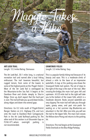
This is a popular family hiking trail because of its beauty and ease. This is a moderate climb of almost a mile to the base of an impressive waterfalls. A map at the parking area shows the Graveyard Fields trail system. The set of steps to the right of the map is the start of the trail. After crossing the bridge, the main trail goes left and upstream. A 0.25-mile trail to the right will take you to the bottom of the Lower Falls, which is a moderate descent. Rocks around waterfalls are very slippery. The main trail will take you through open, grassy areas, and past nice pools for wading on a hot summer day. Blueberries are abundant in the fall. After one mile, you will see the trail to the Upper Falls. The main trail crosses the Yellow stone Prong and returns to the parking lot.
Directions: This trail begins at the Graveyard Fields Overlook on the Blue Ridge Parkway.
FS Rd. 471, where not recommended.
overnight parking is
15
MAGGIE VALLEY VISITORS GUIDE
